Sunday, 6 January 2019

Cranbrook Station


Cranbrook Station was the third station on the Line after Paddock Wood Station and was approximately three and a half miles South East of Goudhurst Station. All the way from Goudhurst Station the Line had risen steadily so there were a lot of cuttings and embankments through an area that skirted the National  Pinetum. Consequently the station was at a higher elevation than any of the others.
The South Eastern Railway (SER) who built the Line in 1893 had hoped to run it all the way to near the center of Cranbrook, having apparently purchased the site of a hop field. They were unable to persuade a few large landowners to sell their land, however, and in desperation perhaps built the Station near the tiny village of Hartley but called it Cranbrook Station. In fact the town of Cranbrook was about two and a half miles away by road.


                                              Cranbrook Station Circa 1910

Looking North, the station had one 300 foot long platform on the downside, it had two goods sheds, each at opposite ends of a long siding (only the nearest one is apparent), then the booking hall, Station Masters house with its three dormer windows, signal box and various maintenance huts. The nearest one to us in the picture was probably for the storage of lamp oil, but sensibly perhaps it was later replaced with a corrugated iron structure. I believe that the houses in the background may have been built for the railway workers.


                                          Looking south, a view of the station from the track bed.

Unlike many of the stations, Cranbrook platform had a brick facing. A part of the goods yard can be glimpsed through the railings between the oil lamps. The station had a small goods loop which was long enough for a few wagons but why the line petered out after the loop I don't know!


                   Looking north again, the small goods loop is clearly visible on the left.


             A lovely old photograph of the platform looking south towards Hall Farm Bridge. 


As if to 'cock a snoop' at the people of Cranbrook the railway line actually veered away from Cranbrook towards Hawkhurst at the station itself!


On the extreme right of the photo a way marker shows the station stood forty-four and three quarter miles from Charing Cross in London.


            Locomotive 31553 heading south towards Hawkhurst, probably in the 1950's


                           Cranbrook Station 10th June 1961 (two days before closure).


                                       Another picture taken the same day.


This station was probably the worst sited of all the stations, it being so far from the town it was supposed to serve. It did however have a few things going for it, the Hawkhurst Line was described as one of the loveliest railways in Britain and many travelers preferred this station to all the others. In the earlier part of the Twentieth Century it was not uncommon for cyclists to come down from London by train and use the station as a base to cycle around Kent and Sussex. Also, it was still the nearest station to Cranbrook.
Surprisingly, in 1949 Cranbrook Station had 58 season ticket holders (more than Horsmonden or Goudhurst) and it would of course also have contributed more to the volume of goods traffic.

                                                      ----------------------------

I paid a visit for the first time today. The site is located down a country lane off of the A229 (the Maidstone to Hastings road.)


                                 Entrance to the lane leading to Cranbrook Station site.


     The old signal box and Station Masters House are still standing. (Likewise the old station       building has been re-vampted in green, for years it was very neglected - see the Wikipedia     page photo of 1985.)


This was the booking hall, there is a 1984 photograph of it in Wikipedia looking very neglected, since then it has been modified and rebuilt.


The old goods yard has become a lorry terminal for Calor Gas and Collison vehicles (they also litter the track bed beyond the old station buildings and up to what was Hall Farn Bridge) but the main goods shed is still intact.


                                    Old railway sleepers border a  parking area.

It is nearly sixty years since the railway closed and it still haunts me, its scars left a haunting reminder of it's recent presence in the village when I was a child. Thank you for caring too! I know this blog often has punctuation and spelling mistakes but people still look at it, I had 129 page views from Russia this week and it is gratifying to know that there are other people who feel similarly to me.

Saturday, 14 July 2018

Goudhurst Church, Smuggling and the Gibbet


I wanted to do a piece on Goudhurst Church and some of it's history, particularly smuggling which was rife in this area.
The church could be seen from Horsmonden platform and from the train on large parts of the line as it skirted around Goudhurst and it was said that from the tower people could watch the progress of trains from their smoke trails for miles.I had meant to do this months ago but apparently it was not safe to visit the church tower as some yobs had stolen lead from the church roof.
                 
                                                    ----------------------------------------------


Goudhurst is one of the highest villages in the Weald of Kent, some parts are at over 400 feet above sea level. Early records prove that there was a small church at the top of the hill as early as 1119, since then there have been many additions to the building as the local population increased. It had a 115 foot spire for a while but that was struck by lightening in 1637 and the present church was built with a tower soon afterwards.


At seventy odd feet the church tower is not high, but it is built on the highest point of land for miles around. The Star and Eagle Hotel, a smugglers pub,  (right) stands next door, (both played a part in the events of 1747).


                                                           The main aisle today


The church still has a few stained glass windows but most of them were blown out when two German parachute bombs exploded nearby during the Second World War.


There are several memorials to the influential Culpepper family, (merchants) who lived in nearby Bedgebury in the 1500's.


                                      The smuggling epidemic of the mid Eighteenth Century

During this period, as Britain was able to colonize more countries with it's advanced seafaring technology of the time it was coming into conflict more and more with other peoples and Nations. Britain required an ever bigger army and navy to fight all these conflicts. Vast sums of money were required, so the Government slapped heavy taxes on imported goods and on it's colonists to pay for it's wars.
             The Weald of Kent and Sussex was a large heavily wooded, hilly and sparsely populated area which came within twenty miles of London to it's north and at the other end, down to the south coast. It became profitable to import luxury goods at night from the continent to ports such as Rye and pay local people to move the goods inland towards the London and the hinterland avoiding the heavy excise duties. Poor people could earn five or six times more working as 'mules' than they would working in a field all day, Criminal gangs grew up to organise runs from the coast and their influences grew. They used many of the public houses as unofficial headquarters.
             The only people able to vote at that time were the large landowners, there was no police force and hardly anyone could read or write, the country was made up of  two nations who did not mix together, so that the governments of the day had little understanding of how people lived.
             Solders and Revenue officers were employed by the Government to try to catch people smuggling goods inland. The revenue men tended to operate around the coasts so for the smugglers carrying goods inland, the first few miles were usually the most dangerous.
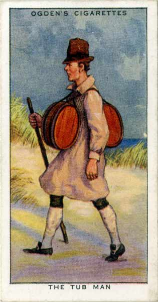
Image result for batman smuggling

Some people were employed as 'tub men' carrying brandy or spirits inland perhaps ten miles in one night.
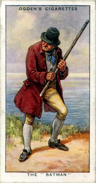

Image result for ogdens cigarettes batmen

Or, if you were of a more thuggish temperament you might apply for a role as a 'batman'. It would be your duty to set about on anyone who may try to interfere with a smuggling operation.

Rudyard Kipling's evocative poem gives a good taste of what it might have been like for the local populace is always worth a read (see link below) but no one kept an account because they would be threatened with execution from the authorities or reprisals from the gang. Of course most people were illiterate anyway so we will never know for sure.

http://www.kiplingsociety.co.uk/poems_smuggler.htm


In response to the crime wave the Government kept imposing harsher and harsher sentences so that it was soon commonplace for captured smugglers to be hanged. When this didn't work the 'gibbet' was introduced. The corpse of the felon was hung up and displayed in a metal cage so that the body rotted and and crows pecked at the corpse. (At that time most people believed that a person could not go to heaven without a proper christian burial, thus the Government felt that they could legislate on a person's soul).

Image result for gibbet images

Captain Kidd's body displayed in a gibbet

The most notorious gang was known as the 'Hawkhurst Gang' they grew to control the Weald of Kent and Sussex and had influence as far west as Dorset. They became more and more violent as the Government imposed stricter and stricter penalties, although no doubt some of them could be philanthropic to the local population. There were a few documented cases of individuals being tortured and murdered when gang members felt that they had compromised the gangs safety. There must also have been many cases of robberies beatings, and rapes which were never published.


                                         The Hawkhurst Gang were checked here.


William Sturt

Enter one William Sturt a son of Goudhurst who had been a corporal in the army. Upon returning home he was apparently shocked at the changes in Goudhurst. The story reads like a Clint Eastwood film.
He managed to raise a militia and begin training them secretly. He also apparently managed to obtain muskets, powder and shot.
An armed confrontation took place around the church on 21st April 1747 the militiamen had been stationed in upstairs windows of houses around the church and in the tower. They knew the gang members were coming and had managed to evacuate some of the population, others were locked in the church. These people had no access to television or books that could have told them the importance of sticking together and being disciplined when fighting a battle and some of them must have felt quite scared. It says something for the leadership qualities of Sturt that they kept their nerve, perhaps he had very good lieutenants.
                 
http://www.goudhurstlocalhistorysociety.org/william-sturt-1718-1797/


                          Militia men were stationed in the church tower and upstairs windows of other                              buildings nearby like this one. 

It is said that some of the gang members let off shots first. (There is a section of the old church door in a frame with lead shot in it). Presumably they were trying to intimidate the locals who were hiding in the church, maybe this strengthened the defenders resolve.


A section of the oak church door from 1747 apparently with lead shot in it.

When the militia did fire back it was a 'turkey shoot' as two gang members were killed immediately, both shot through the head. Other gang members fled but many were soon caught, handed to the authorities and later executed. The bodies of those killed were gibbeted, George Kingsmill the brother of the gang leader in Goudhurst and a William Farrall (from Horsmonden) were gibbeted in their home villages. In Horsmonden there is still a lane called 'Gibbet Lane' so named from where Farrall's gibbet stood. 


Gibbet Lane lies just off from the 'Maidstone Road' close to the village green.


While the defeat of some of the Gang was a victory for the Government, the 'Boston Tea Party' was to take place in December of the same year (which was another event also caused by Goverment taxes on imported goods to pay for colonial wars.) and a precursor to the American War of Independence.

----------------------------------

There is supposed to be a headstone of George Kingsmill somewhere in the churchyard (although the two guides I met did not know where it was) I have seen a photograph in a book of a very weathered headstone with a vague impression of a skull on top, but it could easily be the grave of a black death victim.

The oldest gravestones are closest to the church but I could't find one with a skull on it when I looked.

Another probable urban myth is that there was a tunnel leading from the churchyard to Smugley Farm at the bottom of the hill a quarter of a mile away. This I find ridiculous, although there were secret hiding places and small tunnels built to to hide stashed contraband in many of the houses people would not have had the technology for such a massive enterprise.


The door leading to the church tower.


Views from the church tower.

The Weald of Kent and Sussex, once very rural and heavily wooded seems to have provoked fear to many city people. In all likely-hood there was probably less crime than in London. 'Black Bartlemy's Treasure', a smuggler''s yarn written by Jeoffrey Farnol describes reaching the village of Pembury in the first chapter:-

'And now, as I stood amid that howling darkness, my back propped by the bank, my face lifted to the tempest, I was aware of a strange sound, very shrill and fitful, that reached me 'twixt the booming wind-gusts, a sound that came and went, now loud and clear, anon faint and remote, and I wondered what it might be. Then the rushing dark was split asunder by a jagged lightning-flash, and I saw. Stark against the glare rose black shaft and crossbeam, wherefrom swung a creaking shape of rusty chains and iron bands that held together something shrivelled and black and wet with rain, a grisly thing that leapt on the buffeting wind, that strove and jerked as it would fain break free and hurl itself down upon me.
Now hearkening to the dismal creak of this chained thing, I fell to meditation. This awful shape (thought I) had been a man once, hale and strong,—even as I, but this man had contravened the law (even as I purposed to do) and he had died a rogue's death and so hung, rotting, in his chains, even as this my own body might do some day. And, hearkening to the shrill wail of his fetters, my flesh crept with loathing and I shivered'.


Wednesday, 5 July 2017

Horsmonden Station and the remains of an embankment

               I remember playing with a group of children in the snow in a rugged field south of the station site, at the bottom of the steep hill seemed to be a brick structure with an arch, or arches, and the challenge was to go fast enough to get your sledge or tray under the arch where little snow had settled. I remember quite clearly the long trudge back home with numb fingers and toes in an icy wind. Phillip Smith-Taylor, Bruce Morrison, Mark Dann and Ian Reed had all been in my class at junior school and it was nice to spend time with them again as we had been going to different schools for the last 2 - 3 years.
               I suppose all this is about trying to recapture childhood as well as railway archaeology. In any event I really would like to see this viaduct as I cannot find any reference to it online or in any of the books that I have read. Google maps don't show anything.


Down the Goudhurst Road and this is the Station building (now a garage)
How old is the gate and fence, is it BR era or even Southern Railways era? By comparing an early photograph to this one I am glad to see that the exterior of the building is little changed, all the windows still exit but one chimney stack has gone and the main entrance has been replaced with large garage like doors. Horsmonden station had one 300 foot long platform on the west side of the track (or on the up side), a goods yard behind the platform with two sidings. On the other side of the track was a loop (which could allow trains to pass if one was shunted into it) which connected to a 625 yard long siding which faced a fruit packing plant from which fruit was packed into goods wagons via a loading bay. The station was almost 39 1/4 miles from Charing Cross and about 4 3/8 miles from Paddock Wood Station and about 50 meters above sea level.
In 1949 I believe this station had 50 season ticket holders (not enough to convince BR to continue operations ten years later (although three housing estates went up in the early 1960's), most income was still brought in from farm traffic). Still the village is larger now and more people have to commute (partly because some local industries collapsed after they closed the station) a few more
people today then perhaps?
It is said that there was bunting up in some of the streets of Horsmonden and people cheered the  trains all down the line when they first ran. Perhaps it is hard to imagine now the feelings of liberation that the railway must have bought people. Growing up in a small rural community, enclosed in apple orchards and hop gardens and 'linked' to other places by narrow twisting lanes that never seem to get anywhere I can personally well imagine their feelings. A trip to Goudhurst Station less than two miles away but at least twice as far by road would have seemed like a different world.


Above a well known 1913 photograph of the station with two men and their dogs. The platform was faced with stone. The oast houses in the rear add to the nostalgic aura. Offset from the road these oasts still exist but are now a private dwelling. 


A less common image of the north side of the station showing the little signal box, in the foreground grass is growing up from the long siding.


This image shows the exterior of the station in days before many people owned a car. An unattractive plate girder bridge conveyed trains over the Goudhurst Road up on an embankment for several hundred meters until it came level with the present day apple orchard in the later pictures of this particular post.


This image (apparently taken 10th June 1961) is taken from the long siding looking south. It gives a view towards the railway bridge, and to the right the goods yard and short sidings behind the platform.


Above, about 1 year before closure, H Class steam engine 31553 'blows off' as it arrives from Paddock Wood, these little engines were very reliable and ideal for branch line work from shunting or pushing and pulling carriages. This locomotive outlasted the operation of the line by barely a month. The apple packing plant is on the other side of the tracks and part of the loading bay is just discernable (with a number of oil barrels sitting on top). When I was about six I walked up this part of the track bed with my parents as the sandstone walls of the cutting rose over our heads, and distinctly remember rusting oil drums like these strewn across the track bed. The ugly hoses hanging down the train were for the air operated push-pull equipment.


Above a picture of the station painted in Southern Railway colours on the last day of service in the rain 11th June 1961. Despite the new paintwork, flowers were growing up through the platform cracks and tracks which contradicted the well maintained effect. All the stations had gas lamps on barley twist posts. The signal box was on the other side of the station building and had six levers.


A 'Farewell to Steam' event was held the day after official closure, the event was full of photographers, and this was the last train to carry passengers. This picture was taken from the track a little north of the station. This C class engine (more powerful than the standard H class locomotives of the time) still exists and is now privately owned according Vic Mitchell and Keith Smith in their book.


 These oasts were just south of the station, they later used for warehousing china but are now flats. (Quite a lot of light industry appeared around the station during the railway era like Boddingtons factory). Behind the oast houses the plate girder bridge once carried the line over the road onto an embankment through fields and orchards towards Goudhurst Station.


                                       An image of a steam locomotive sits on one of the cowl vanes.


This rocky wall obscured by trees dates back to the early station era and marked where the bridge was about to cross over the road.


Behind the oasts are yet more new houses which were built over the site of the embankment and the spoil was moved over the road to fill the remaining cutting north of the station site. It's nice that they named it after Mr Lambert (he had a collection of steam traction engines and steam farm machinery and these beasts would appear at village fetes.


The embankment or  viaduct must be in this direction round the back of the oasts.


I wander up the path to a water tower among apple orchards then turn left looking for evidence of the old line.


Bizarre. beyond the beautiful apple blossoms and over a fence seems to be a scrap yard for London buses. Just beyond the fence would be the site of the railway track.


                                       Above a little of the trackbed. Note the old post on the left.

Down and to the north I can see an arch in the distance but it looks very private now and I don't want to scramble over the fence. I retrace my steps back the way I had come and look for an adjacent field nearer to the Goudhurst Road. Eventually I find one but it is lined with barbed wire. Anyway I hop over and accross two fields but it is starting to look private again. An elderly man calls out from his garden to ask if he can 'help' me and I am led into his garden. He seems very sympathetic when I explain what I am looking for. (It turns out that I am now at the back of the houses in Lamberts Place). Apparently two years before a group of teenagers had come along and smashed up the neighbour's caravan windows. As a consequence perhaps his neighbours are hostile to strangers. However, as his fence had blown down he let me pop through and sneak a couple of pictures. I can now see that it was never a viaduct but access under the embankment for farm traffic.

                                                                     
                                                                             Found it!


The structure is built in the same redish brick as the tunnel and Swigs Hall Bridge. I should have taken more photographs. My childhood memories had become distorted as it was never a viaduct but just an embankment. Now it is quite obvious that the embankment drops down to the right and south (at 1 in 117).

Saturday, 1 July 2017

Pattenden Lane Siding


Courtesy of Brian Hart. Pattenden Lane siding bye 9th June 1961 was very overgrown. Here H Class 31530 heads south towards Hawkhurst with Pattenden Bridge in the background.


I have finally reached the site of Pattenden Lane Siding which was just beyond Pattenden Bridge on the Bedgebury Road to the south of Goudhurst. There is very little to see but like Rise bridge the road rises considerably, today all views are obscured by thick vegetation.


                    Looking south from Goudhurst the land rises markedly at Pattenden Bridge.


A small sign on the top of the bridge says 'PWH 1502 A'.

                                                       -----------------------------------------

One of the campaigners for a railway was the Rt Hon Alexander J B Beresford Hope, a local Tory MP who seems to have owned much of the land to Hawkhurst, it took years and years to finally build the line and his resolve must have been severely tested at times, he was offered a station on his land but he wisely refused in favour of a farm siding. Pattenden Lane Siding was used for longer than Churn Lane Siding Horsmonden, so it must have been fairly successful. The site was about 1 mile down from Goudhurst Station and nearly 8 miles from Paddock Wood Station.


This is the site of Pattenden Lane Siding today, somewhere in the distance among the trees is      Pattenden Bridge.

I took a walk along the footpath to the side in the hope of seeing something (for example there had been a pile of gravel which appeared on many of the old maps for a long time) but all I saw was an old railway sleeper!


This sleeper must have been old when the line closed, it looks decrepit and is in a far worse state  than the others that I have seen.


After the farm siding the trackbed follows the right hand fork and soon veers to the south away from Goudhurst. The left fork leads to Smugley Farm.


      Taken from the trackbed, the line passed within 100 yards of Smugley Farm famous for it's smuggling history (there was supposed to be a tunnel from St Mary's Church, Goudhurst over half a mile away, please see my next posting for more on that).


   The trackbed , now a farm track, soon bent sharply and there was an accommodation crossing so drivers were obliged to slow right down and be extra vigilant, particularly during the hop picking season. The line rose quite sharply here and it is obvious to the naked eye  The gradient was 1 in 85 after the bridge, soon rising to 1 in 60.