Friday, 29 May 2015

Churn Lane Level Crossing and Siding

After Willow Lane level crossing the next road to be crossed from Paddock Wood Station would have been Churn Lane.


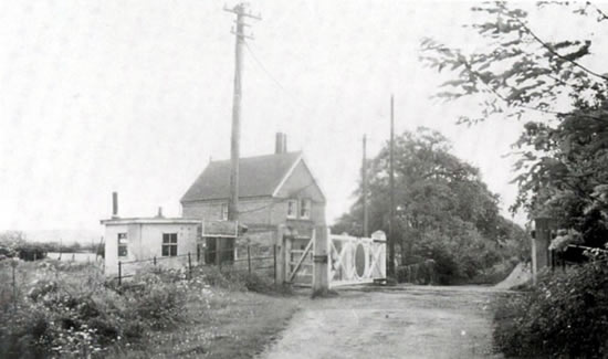
Courtesy of Brian Hart. This wonderful though blurry image appears to have been taken from the top of a signal early in the twentieth century. Perhaps the gate keeper and his wife are pictured here? Behind the coal trucks in the siding can be seen the gate keepers cottage. It is rare to see an image of the siding when the ballast was fresh and before weeds had grown up.


Courtesy of Brian Hart. A view of Churn Lane siding looking towards Horsmonden soon after a train had smashed through the gates (the ropes had to act as temporary gates before their repair). On the left a mile post shows that the crossing was thirty-seven and a half miles from London Charing Cross.


Courtesy of Brian Hart. Looking towards Horsmonden again but from the end of the sidings, as the line began its mile long climb at 1 in 66 up to Horsmonden Tunnel. I believe that the warning bell on the telegraph pole was added following the above mentioned accident to help warn the gate keeper that a train was coming.


Courtesy of Brian Hart. Taken from the lane. A crossing keeper watches from his box as a train rumbles towards Paddock Wood. This sturdy shed appears to have stood for many years before finally being replaced by a small prefabricated structure not long before closure.


Courtesy of Brian Hart. Looking in the direction of Paddock Wood towards Churn Lane and the keepers cottage from the siding itself.


Looking down Churn Lane one bright evening. The railway once crossed the road diagonally from the opening in the hedge on the right hand side to further down the road near to the house on the left.


To the north the track curved round on the right hand side of the above field towards August Pitts Farm (now known as 'Beechland'), Old Hay Farm, Willow Lane and then Paddock Wood Station about 2.68 miles north, Charing Cross was 37.5 miles from here.. At this point the line had been climbing at 1 in 78 (from 1 in 1,000 before that) but now in Horsmonden parish the Wealden hills begin.


The level crossing keepers house still stands although the gates are long gone (I have a very vague memory of seeing them as a small boy). This is another red brick house with its distinctive downstairs bay window and a finial on the roof.


 As stated, up to Churn Crossing the line climbed at 1 in 78 but this increased to 1 in 66 soon after crossing the road, for a mile until Horsmonden Tunnel. The old steam locomotives that were allocated to work the line sometimes struggled to make the climb up especially if the rails were icy or if pulling heavy loads like hop pickers' specials. One broke down in Horsmonden Tunnel once and the fireman had to walk along the track to Horsmonden Station so that they could phone Tonbridge for another locomotive to assist. The sidings were perhaps badly sited due to the rate of incline (1 in 78 one end and 1 in 66 the other) it was preferable to leave trucks at the northern end as they were less likely to roll.


Eh, looking towards Yew Tree Green Road and Horsmonden (the new fence obscures the view but the direction of the track bed can be seen from Google maps. Beyond the fence, sidings were added after the line opened. The SER were taken aback by the amount of goods traffic when the line opened and were obliged to add these sidings. These were used regularly until 1940 after which their use declined, presumably the trend to move goods traffic onto our roads had already began by then.


Saturday, 23 May 2015

Paddock Wood Station


Paddock Wood station approach today. The entrance is on the up side (London bound side). Originally the main buildings were on the down side and although grand in style they were deemed superflous and eventually demolished.

Probably less than 20 metres above sea level the station was built in 1842 by the South Eastern Railway (SER) as a stop on the way from Redhill or London to Folkestone, Dover and the Kent ports. Originally known as 'Maidstone Road' as then it was the nearest station to Maidstone, it later became known as 'Paddock Wood' after the wood that once occupied the space. The platforms were built four tracks apart which meant that powerful locomotives could thunder beween London and the coast without needing to slow down. The other two tracks adjacent to the platforms were for stopping services. In 1844 the Medway Valley Line was built though which connected up Maidstone and a few surrounding villages with Paddock Wood, the station would have grown in importance as a result. Books show diagams of the station with numerous sidings for goods traffic all of which have now dissapeared on the up side at least.

It seems strange that nobody lived here in 1842 but with the trains came work and people and Paddock Wood is a real railway town. Not surprisingly there are no very old buildings in the town. One other thing, the station gets a mention in one of Charles Dickens books 'Dombey and Son' when a character is killed off trying to cross the line . Accidents were probably quite common in the nineteenth century, indeed Dickens himself was involved in a horrible accident in 1865 near Staplehurst, two stops down the line (on a train operated by the SER).
http://en.wikipedia.org/wiki/Staplehurst_rail_crash

Some preliminary work on the Hawkhurst branch began in 1879 but money soon ran out, however, part of it was up and running by 1892 which further enhanced Paddock Wood Station's importance.

--------------------------

I want to buy a platform ticket to take some pictures from the platform but there are no staff and the one ticket office is closed, I am forced to go to the one machine ('robot' to me) but that doesn't work. While I am struggling with the robot three people ask me if there is anyone around who can help? A grandmother is taking her daughter and grandchildren up to London for a trip and finds it rather daunting. At this point a digitised voice (robot to me) 'apologises' and announces that the driver of the next train to Victoria has been taken ill, so it has been cancelled (they obviously don't pay relief drivers any more). Some older people start muttering to themselves about this but I notice that the teenagers immeditely return to their iphones. In the corner a guy from some franchise tries to sell people coffee.

I wander onto the platform (without a ticket), I used to come here every working day in the 1980's on my way up to London and wait on the upside platform, at the time I never knew that the bay on the south side of the platform once served the Hawkhurst Branch. Then there used to still be the original rusty rails and another siding beyond (used by a fruit importer) for goods traffic. Question, when did you last see a goods train in the South East? In my case I have hardly seen one in thirty years.


Looking west towards London, the platform has been lengthened to the east at some point. Up until 1961 the Hawkhurst branch signal box would have stood here (before the platform was lengthened). It was a gantry like structure raised up on steel rails and trains would have to pass beneath it. Signalmen would need to climb up three flights of steps to enter the structure.


This is the remains of the bay platform. (It looks like the platform has been widened to allow more passenger space at some point prior to 1989).


Next to the end of the new platform extension is a museum exhibit, a section of the track preserved where it once ran parallel to the main lines. (I believe that this section of track survived  until it was lifted early in 1989).


Outside the station again. Here is a view of Paddock Wood Station No 2 Carpark  which has been built over the southern bay track and adjacent sidings.


This was not the original platform edge. As I stated earlier it looks like the platform has been widened. 


More views of the bay platform from the overflow car park, the last one shows the end of the bay platform, the peeling paint on the edge is perhaps 30 years old? The water for the steam locomotives serving the Hawkhurst Line was a column with a big wheel, adjacent to the end of the bay platform and once stood two tracks over from where this picture is taken from. 


Image result for paddock wood and hawkhurst railway images

31553 in the Bay Platform

Willow Lane Level Crossing (near Paddock Wood)

Walking down Parsons Green Lane (still quite rural but with lots of traffic buzzing past) I see a sign on a telegraph pole giving notice of planning permission for a new solar farm and it's not long before I see row upon row of solar panels marching across a vast field. Eventually I turn left into what was the very rural Willow Lane. In the foreground is a deep ditch full of water and beyond are endless rows of solar panels, whilst a small sign declares it to be a lorry free zone.
                         It's easy to see where the level crossing was, as in the one photograph I have, the road is raised up slightly for a few yards where the crossing once was. This was the first of five or six level crossings on the line. For each gate (both sides of the road was once supported  by sturdy concrete posts, now there is only one left standing on the north eastern side).

Willow Lane from the west looking towards the site of the level crossing with cow parsley in abundance


One of the original level crossing posts angled diagonally as the railway crossed the road at an angle.


Another view of the post with the back of some solar panels in the field beyond. This gate is new but the Google maps view shows a decrepit affair, there you can also clearly discern the direction of the track bed as the soil is a different colour across the field heading towards Queen Street Bridge a quarter of a mile to the north. 


I think this is the site of the other concrete post on the north side of the road and apparently not removed so very long ago.

Willow Lane Crossing was about 1.25 miles down the line from Paddock Wood Station and just over 36 miles from Charing Cross Station. I think at this point the track was supposed to be climbing at 1 in 471. Google maps road view show a very flat field reminiscent of Flanders or Norfolk and as the name Willow Lane might imply, the fields can get very wet on low lying land where willow trees thrive. Looking at the depth of the ditch I think that flooding has always been an issue here.


willow lane crossing

I think that this is an image of Willow Lane Crossing. Note how much smaller the cottage was before extensions were added (the telegraph poles show that there was at least a telephone connection) and how the road was raised up slightly.


A view of the level crossing sight from the east, in the ditch can just be seen the arch allowing water to pass underneath the approach to the level crossing. Also the house in the distance (much changed) would have been built in the 1890's by the South Eastern Railways, for the gate keeper.


Water flows constantly through the arch which had to support the full weight of a heavy locomotive and carriages when it was built. I would hazard a guess that it is solid brick throughout. Again the reddish bricks are apparent, they must have used thousands on the railway construction! Some preliminary work was performed in 1879, this may have been one of the first builds.


Above the direction of the track bed heading towards Old Hay Farm and eventually Horsmonden. It looks idyllic doesn't it? but unfortunately the fields to the left of the track bed are now full of old cars and lorries from a second hand car business, and beyond that are prefabricated structures whilst more cars straddle the landscape and the track bed for the next half a mile or so.


Beyond the cow parsley and the ditch another view of the solar farm which was once perhaps apple orchards or hop gardens. They have planted three or four layers of fruit trees around the perimeter so that in time it will look far more pleasing.from the road. Probably the farmer was made an offer for the land from 'Gelectric' that could not be refused.
 Above, the crossing keepers cottage (with extensions on both sides). The crossing keeper was required to come out of the house a few minutes before the train was due and padlock the gates across the road prior to the train passing through. (I doubt if there was much road traffic here then though). I have thought about this a lot recently, would you want to do this job, all you had to do was open and close a gate a few times a day and for that you would get free accommodation and a small income. I think I would go crazy as I would be housebound and isolated six days a week. The early photograph of this cottage does however show three telegraph poles nearby, hopefully at least they had a phone (it may have been a requirement of the railway).
There was an accident here once during a storm one evening when the lady keeper ran out to open the gates for a train but in her haste to get back inside she did not secure them properly. The result was that the strong wind blew them back across the line where they were made into match wood by the train. Nobody was hurt though.
The main engineer on the railway project was a Mr Seaton but the more famous Holman Fred Stephens as resident engineer played a very active part in much of the work, including designing most of the railway cottages, it is likely that he designed this house. I notice that the cottages at Churn Lane and Smallbridge are of a very similar style in red brick with a downstairs bay window at the front.


Tuesday, 5 May 2015

Book Reviews and Websites

I have only read three books about the Hawkhurst Line but I would urge people to read at least one (if you don't want to read another one afterwards then this subject is not for you).


ISBN 0 9523458 3 8               'The Hawkhurst Line'. First published 1982. A paperback of 32 pages most pages with black and white photos it is an excellent introduction to the forty plus years of campaigning from the residents of Cranbrook, Hawkhurst, Goudhurst, Horsmonden, Brenchley and Lamberhurst for a railway, building the line and some of the more memorable events before it joined the list of casualties just before Beeching. I bought my copy a couple of years ago from the Bluebell Railway shop it was only £3.50. I would recommend this book as an introduction to the subject.


ISBN 0 906520 66 5         'Branch Line to Hawkhurst' is much like the above but contains 96 pages and it has a lot more historic photos and is predonimantly picture based. Vic Mitchell and / or Keith Smith obviously also know a lot about steam engines as they go into more detail in that area. The photos are displayed as the book works its way down the line from north to south. Published in 1989 it cost me £7.95 a few years ago.


ISBN 1 874103 54 2         'The Hawkhurst Branch' a monster 252 page account. Brian Hart has done a tremendous amount of research into this and I feel indebted to him as a reader. Apparently 60 % of the photographs in this book have not been published anywhere else. Published in 2000. If you read this you will be hooked on the subject for life. This book may cost you about £25.00.

These books should all be available on Amazon, Ebay or try www.britishrailwaybooks.co.uk .


------------------

I did email some of these authors to thank them and update them on what I am trying to bring about. Brian Hart thanked me for liking his book and mostly talked about what a wonderfully interesting line the Hawkhurst line was and how if it was managed well it would have made a profit. Brian has been involved in trying to reopen several closed lines, The Eltham Valley line in East Kent (another Holman Stephens enterprise),  the Kent and East Sussex Railway (also Stephens, many of the signals and lamp posts from the Hawkhurst line ended up there) and for the last few decades part of the Wealden line. In his book he said that when they were trying to save the East Sussex railway twice BR came back and suggested that they might want to put their efforts into trying to preserve the Hawkhurst line which was less loss making.
               Peter Harding who grew up in Goudhurst and feels more of a personal affinity with the line was very encouraging. He said that he had gone to Horsmonden to watch Dennis Compton and Arsenal's first team play a Horsmonden Eleven cricket team during which he had sneaked across to look at the cutting and was surprised how deep it was. He said that he was 'amazed' that network Rail were willing to look into reopening the Line but if sucessfull it would take years to reopen as they would have to repurchase all the land again.

------------------


Websites:

I have only found one so far - 'Forgotten Relics' http://www.forgottenrelics.co.uk/tunnels/gallery/horsmonden.html

It gives a full account of tunnels, viaducts, bridges and cuttings explaining the engineering aspects and history and sometimes coordinating campaigns to save structures.

Saturday, 2 May 2015

Horsmonden Church, Simon Willard and Jane Austen's Grandparents

As I am near St Margarets the main village church which is just off of Brick Kiln Road, and it has an American connection, and I was gratified and amazed to get 124 page views from America a few days ago, here goes: (As Mr Mc Argle say's in 'Twelve Angry Men' 'It's so important for an older man to be listened to even just once'.


                              Approaching the church with oast houses in the foreground.


This is the original medieval part of the village (a church and two or three houses is all that remains over a mile south of the main part of Horsmonden perhaps because in about 1665 the great plague of London spread to this area and everybody fled or perhaps because the iron industry was taking off a mile or so north of here.


I'll pop inside through the 15th Century porch.

This place dates back to the 1300's, it had a tower for defence of it's citizens in early lawless times.


(It really feels like I have stepped back a few Centuries in time and it is very peaceful). The above stained glass windows were commissioned by American relatives of Simon Willard who was born in Horsmonden and became an early American pioneer arriving in the USA about 1634, he helped to found Concord in Massachusetts .  He was probably a 'puritan' and felt jaded with this country due to the antics of King Charles I who had catholic sympathies and believed in the divine right of kings. (A few years later the King declared war on his own parliament and eventually lost but the conflict inspired some puritans to return to England to fight on behalf of Parliament). Certainly Simon Willard  was recorded as having had a reputation for fairness in the way he treated colonists and Indians alike.


The window on the right was commisioned for Willard's 6 x Great Granddaughter who was an early feminist, educator and suffragist. She was national president of the Womens Temporance movement in the USA for 19 years at a time no doubt when alchoholism was a very real problem. If you have ever seen 'The Cure' by Charlie Chaplin you may realise at least how bad the problem was reputed to be by the early twentieth Century.


                                                        Outside the church again.


These heads are not gargoyles, as gargoyles would have waterspouts in their mouths but might be 'chimera'  other mythical charactors (according to my sister).    


The above two images are the grave of Jane Austen's Grandparents who were wealthy wool merchants, and there are other early relatives buried in the churchyard.


To the south the land drops towards the Teise valley.


To the east about half a mile away would be the site of the Hawkhurst line.


A local hopfield. Once hopfields were as common as apple orchards in this part of Kent but advances in brewing techniques and cheap Belgium imports have largely killed off the trade. I grew up with these as a common sight and the smell in late August and early September was glorious.

Brick Kiln Lane Bridge, Horsmonden

About 1km  (0.7 miles) south of the station site there was another plate girder bridge that crossed the road on an embankment. This was on Brick Kiln Road and adjacent to Nevergood Farm. Sadly this has now been dismantled but in this case at least the bricks seem to have been removed and not left to blight an adjacent field.


                                                 Above: A poor image of the bridge circa 1955.

                                         
                                   Looking east towards the site of the bridge today. You can tell that there are farm trails to the left and right which now run over the site of the track. The track was still dropping from Horsmonden tunnel at 1 in 117 (or 1 in 110)


                                    This is looking north, the site of Old Nevergood Farm.


                                              Looking south towards Goudhurst Station.

I would very much have liked to have taken a closer look down here to see if there is anything left but it is obviously very private and the gate is padlocked so I continue on.


Seen from the west the embankment graduating the drop down into the Teise Valley still exists. Trains were delayed for some time near here in the October of the first year of operation, It appears that there was several days of heavy rain and because the grasses had not colonised the embankment properly much of the embankment subsequently collapsed.


Above a view of Goudhurst village from Brick Kiln Lane. It would have been quite impossible to run a railway up there, so they were forced to cite the station 1 mile away from the village.